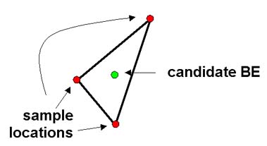
For point data that are numeric but not regularly spaced like raster data, BoundarySeer uses a method called irregular wombling (also called triangulation wombling in the literature). In this method, the points are first triangulated using a nearest-neighbor network (BoundarySeer uses the Delaunay triangulation), and then surface gradients are estimated at the center of triangles (see figure below).
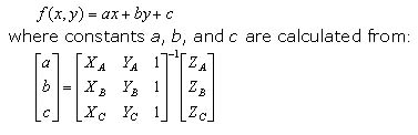
Using the Delaunay triangles as an approximate surface, a plane is fitted to the values of each variable at the vertices of each triangle (equation below). The gradient magnitude and angle are estimated at the triangle's centroid using the same method as with raster wombling (see equations 2-4 on that page). Boundaries are determined through applying BLV thresholds and subboundary connections are made through gradient angle thresholds.
Applications include the use of irregular wombling to detect ecotones in forests (Fortin 1994) and the edges of distinct soil zones. Fortin and Drapeau (1995) found that it correctly detects boundaries in both simulated and real environmental data.
See also: