
Spatial features can ease network editing when the study area is irregularly shaped and a number of inappropriate links have been created. Go directly to the instructions.
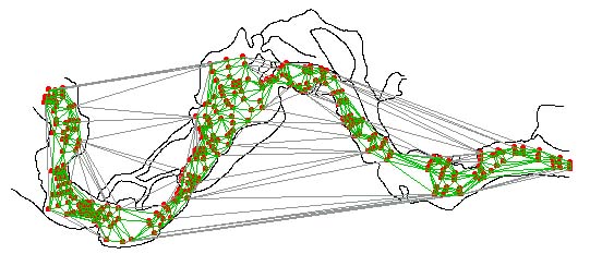
For example, in the spatial network for stream data below, a number of Delaunay network connections and triangle centroids, where Boundary Likelihood Values (BLVs) are calculated, are on the land. These connections are inappropriate because the data contain no information about the land.
While BoundarySeer has identified some of links to deactivate (in gray), a number of inappropriate links remain in green. Instead of deactivating individual links by hand, you may exclude links using a spatial feature. The spatial feature can be imported into the project from another source, such as a digital USGS map. The imported outline can be used as a tool for intersecting (and selecting) all links that occur outside of the study area. The illustration below shows the spatial network and the outline of the stream bed, after the stream outline was used to deactivate links that intersected it.
![]() When you choose to edit the network, BoundarySeer automatically goes into edit mode. Under "Spatial Network" on the main menu, choose "Select Links Using", and then select "Line Intersection." Or, hit the line intersection button on the toolbar (not active unless another data set has been imported into the project).
When you choose to edit the network, BoundarySeer automatically goes into edit mode. Under "Spatial Network" on the main menu, choose "Select Links Using", and then select "Line Intersection." Or, hit the line intersection button on the toolbar (not active unless another data set has been imported into the project).
This will bring up the Line Intersection dialog box. Choose the data you wish to use as a spatial feature from the pull-down list (you must have already imported it into the project).
![]() The links that intersect the "cookie cutter" spatial feature will change color. Next, from the Spatial Network menu, choose "Deactivate" or hit the deactivate button, . The links that were the "selection" color turn to the deactivated color (usually gray), and are not included in later analyses.
The links that intersect the "cookie cutter" spatial feature will change color. Next, from the Spatial Network menu, choose "Deactivate" or hit the deactivate button, . The links that were the "selection" color turn to the deactivated color (usually gray), and are not included in later analyses.
![]() Save your changes, by choosing "Save Changes" from the "Spatial Network" menu or hit the save button.
Save your changes, by choosing "Save Changes" from the "Spatial Network" menu or hit the save button.
![]() Choose "Stop editing" from the Spatial Network menu or from the toolbar to turn off the edit mode. You can also stop editing by deleting the network layer from the map. BoundarySeer will prompt you to save your changes if you did not already save them.
Choose "Stop editing" from the Spatial Network menu or from the toolbar to turn off the edit mode. You can also stop editing by deleting the network layer from the map. BoundarySeer will prompt you to save your changes if you did not already save them.
See also:
Next step: