You might think of a boundary as a set of connected spatial locations that separate areas with different characteristics. For example, a boundary for a toxic waste site separates areas of high pollutant concentration from adjacent areas of low concentration. A boundary for a species' range limit delineates where the species is found and where it is not. An economic boundary distinguishes a poorer community from a wealthier one.
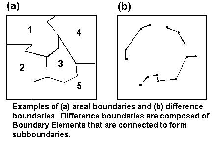
Boundaries may be formally defined as edges of homogeneous areas (areal boundaries) or as spatial zones of rapid change (difference boundaries). Areal boundaries are closed and fill the study area (Figure a below). Examples of areal boundaries include the edges of agricultural fields, watersheds, political boundaries, and forest clear-cuts.
However, the processes that give rise to boundaries are not always associated with homogeneous areas. Difference boundaries, zones of rapid change, describe this situation. A cliff edge illustrates a difference boundary—the edge marks a potentially dangerous difference in elevation. For difference boundaries, the values of the variable immediately to one side of the boundary are very different from values immediately to the other side. Difference boundaries are often open, meaning that they appear as line segments that do not enclose an area (Figure b below).
Boundaries may be further distinguished by other characteristics. Boundaries may be natural (such as a shoreline) or artificial (such as a road). Some boundaries, such as edges of forest clear-cuts, may not be easily classified as natural or artificial. Boundaries may be crisp (well defined) or fuzzy (imprecise). Both areal and difference boundaries can be fuzzy. Fuzzy boundaries occur when the zone of change from one type to another is relatively wide. Additionally, boundaries may be generated by a single variable, such as the concentration of a toxin, or by a suite of related variables, such as ecotones defined by multiple species' densities.
See also: