This file format consists of three separate related files, all with the same file name but different file extensions (*.shp, *.shx, *.dbf). Once you tell ClusterSeer where to find the *.shp file, it will look in the same directory for the *.shx and *.dbf files.
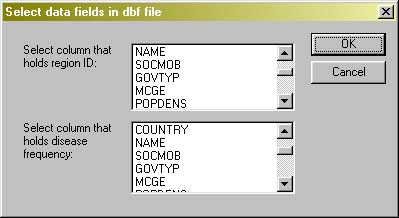
Once you select the file to use, ClusterSeer will prompt you to choose the columns in your *.dbf file that contain required data. Below, you can see the dialog for matching columns to required data for the local Moran method.
Once you have selected the columns, ClusterSeer loads the data. If you cancel at this point, the procedure will cancel.
Note: ClusterSeer will send you an error message if your data do not meet the shapefile requirements. Make sure to prepare your data with a GIS data editor so that it does not contain self-intersecting polygons. A polygon is called "self-intersecting" when two or more of its borders intersect anywhere except their endpoints.
![]()