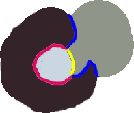
In polygon wombling, the spatial unit is a polygon, rather than a point or a raster. Polygon wombling is similar to categorical wombling, in that dissimilarity metrics, rather than surface gradient magnitudes, are used to quantify Boundary Likelihood Values (BLVs). A dissimilarity value is calculated for each pair of adjacent polygons, adjacency is defined as sharing a border. Candidate Boundary Elements (cBEs) are the lines that separate the compared polygons, even for complex shared borders. In the figure below, the cBE between the light gray and the black polygon is outlined in bright pink and the outline between the light and dark gray polygons in outlined in yellow. The cBE between the black and the dark gray polygons is outlined in blue.
In polygon wombling, the variables have uniform values across the surface of the polygon. If the location of the polygon boundaries is uncertain, or you feel the values of the variables are not uniform over the polygon's surface, you might consider performing a wombling analysis with location uncertainty (See What is location uncertainty? for more information).
See also: