The import data option appears whenever you open a new project. You can choose to import additional raster data sets at any time by choosing "Data" from the main menu, and then choosing "Import", and then "Raster". BoundarySeer can import a number of raster data types, including ENVI® files (BIL, BIP, and BSQ), image files (TIFF, JPEG, BMP), georeferenced images (GeoTiff and DRG), digital elevation models (DEM), and GRID ASCII.
ENVI® rasters can be saved in one of three different file formats, band sequential (BSQ), band interleaved by line (BIL) and band interleaved by pixel (BIP). BoundarySeer can import any of these files directly, as it reads in the georeferencing information in the header.
TIFF and JPEG image files can be imported into BoundarySeer as rasters. These files contain no georeferencing information, and so they must be georeferenced on import or by using the georeferencing dialogs found from the "Data" menu. BMP files cannot currently be imported into BoundarySeer, but that capability is expected soon.
GeoTIFF and DRG files are, essentially, georeferenced TIFF files. These files are imported directly into BoundarySeer unless the file contains insufficient georeferencing information.
DEM files are USGS digital elevation model files that contain georeferencing information. BoundarySeer can import these files directly.
The GRID format is a proprietary ESRI® format for raster data. GRID files contain only one variable, although you may import several GRID files with the same spatial coordinates: choose a custom import.
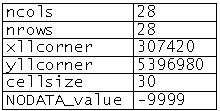
To import GRID ASCII files, the file must begin with a header - the first 5 lines in the header are required, while the sixth (listing a value assigned to missing data) is optional. The first 5 lines should appear automatically when the file is generated from ARC/INFO®, but if you are having trouble importing files, this may be the source of the problem.
In the example file fragment above, the first two header lines describe the number of columns and rows in the file, and the next lines provide the coordinates for the raster that represents the lower left corner of the data set. Some files present "xllcenter" instead of corner - this is an acceptable format as well. The next header line provides the cell (pixel) size, and the optional sixth line is for the missing value code. After the header, the string of data for each cell appears, starting in the upper left corner of the grid, with each value separated by a space (space delimited) and each row separated by a carriage return.
For more information on GRID ASCII files, please go to the ESRI website.
See also:
ESRI® and ARC/INFO® are registered trademarks of the Environmental Systems Research Institute, Inc.
ENVI® is a registered trademark of Better Solutions Consulting LLC.